Memories from the Grafton Friendship Club at the turn of the century (1999)
The 1999 Friendship Club together recounting their memories
History of the Parish with references from 1500s and earlier.
Legislation enacted in 1843 made it possible to divide large rural parishes without the need for a separate act of Parliament, which enabled the Church of England to compete with the nonconformists by building new parish churches in outlying districts. Grafton is a good example of this process.
The present civil parish is a Victorian creation that followed in the wake of the ecclesiastical partition. It is large, remote, and full of variety, and embraces no fewer than six settlements (East and West Grafton, Marten, Wexcombe, Wilton, and Wolfhall) which until 1844 occupied the southern portion of the enormous ancient parish of Great Bedwyn.
This was in turn part of the larger territory of Bedwyn – probably a Saxon multiple estate – which included also Little Bedwyn, Burbage, and parts of other parishes. There were medieval chapels-of-ease at Marten, Wilton and East Grafton, but after they had fallen into disuse (East Grafton was still functioning in 1579) a round trip of at least 12km to church at Great Bedwyn would have been involved from the more remote hamlets. In practice some worshippers attended nearer churches in neighbouring parishes, such as Burbage (where some Grafton baptisms occur in the registers), and others – if they bothered to attend church at all – might have preferred the nonconformist services held at Wilton from 1812 and Grafton from 1820.
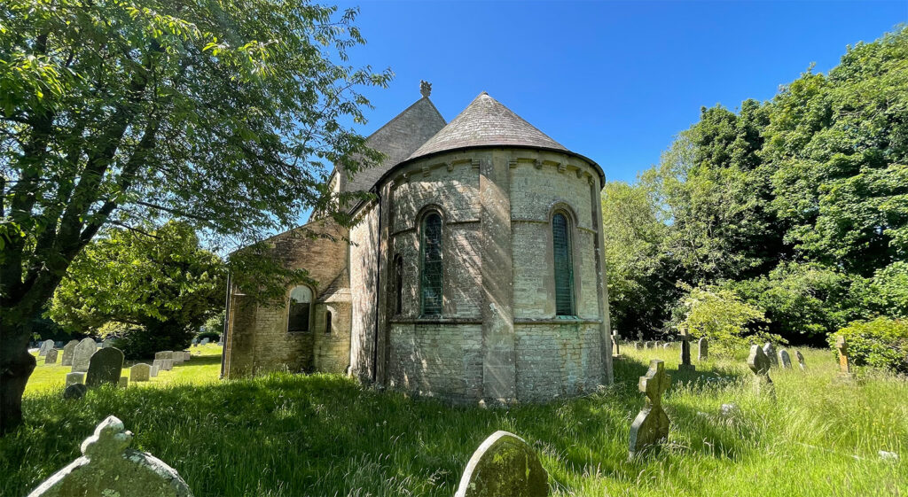
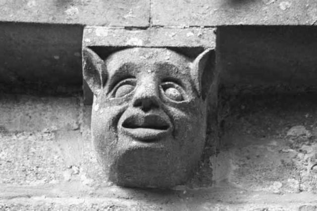
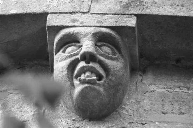
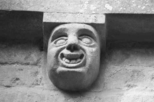
A new parish church beside East Grafton Green was begun in 1842 and completed in 1844. It has a ‘rich, solemn and Christian character’, as the Gentleman’s Magazine remarked of its sanctuary, and its ponderous Romanesque lines are relieved only by some menacing gargoyles which squat on the tower roof. It was the work of Benjamin Ferrey, a disciple of Pugin and diocesan architect to Bath and Wells, and was largely paid for by the Ailesbury (Bruce) family.
Too eager to show off his new church Lord Bruce took a clerical friend to inspect the nave vaulting before its mortar had set. It fell, killing the clergyman ‘in a manner most awfully sudden’ (according to his memorial), and narrowly missed the earl, who was enveloped in a cloud of dust. A wooden roof was built instead. The churchyard reflects to some extent the geography of its new parish, with Wilton, Wexcombe and Grafton burials roughly grouped to north, south and west respectively.
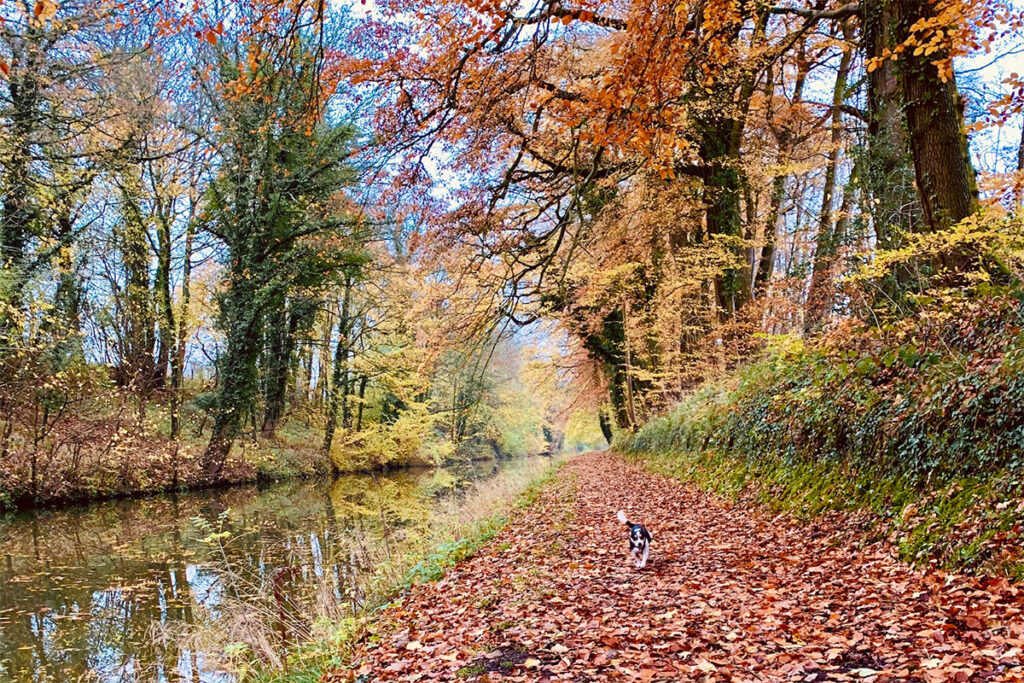
Although largely a chalkland parish, all Grafton’s settlements except Wexcombe lie on a finger of greensand which extends eastward from Pewsey Vale. Streams flow north-east across the greensand from the springline to feed the Bedwyn Brook (and ultimately the Thames), but near West Grafton a headwater of the Bourne sets off on a southward course which ends in the English Channel. The chalk downland rises to over 260m on Wexcombe Down near the south-eastern edge of the parish, and close to Tow Barrow, a ‘short’ neolithic long barrow.
Three ancient roads cross the parish roughly from north to south. The Roman road from Mildenhall to Winchester takes a virtually straight course through the parish, irrespective of contours, and passes close to Marten and Wilton. It remains in use as public roads south of Marten and between the former Nags Head (then Tipsy Miller) pub and Wilton Hill. A minor road which leaves the A338 near the Nags Head to climb the escarpment beside Wexcombe, and continues as a fine ridgeway almost to Collingbourne Ducis, is shown on Ogilby’s road map of 1675 to have been part of the main road from Salisbury to Oxford. It was turnpiked in 1772 and, although no longer a road of any official importance, it is still the quick and favourite way of travelling between the Hungerford area and south Wiltshire.
Below it to the west a parallel track from East Grafton to Brunton and Collingbourne Kingston is described in charters of 961 and 968 as weall weg, ‘the native Britons’ road’. The A338, which runs east–west across the parish, was never turnpiked, but seems to be an eastern continuation of a Saxon military road, the Pewsey Herepath. On the greensand around East and West Grafton several minor roads shown on a map of 1792 have disappeared. One, which ran from the A338 near Kinwardstone to Freewarren, was said in 1904 to have been abandoned because it was a favourite haunt of gypsies.
The Kennet and Avon Canal, which was opened along the northern edge of the later parish in 1809, served not only to improve communications to this somewhat remote area. Also, in order to supply water to the summit pound (or highest point) of the canal, the company found it necessary to create a reservoir by damming the headwaters of the Bedwyn Brook near Crofton. The resulting lake, which extends almost from Crofton to Wilton and Freewarren, is officially called Wilton Water, but is known locally (and on the signpost in the village) as ‘The Wide Waters’. Water from the reservoir was raised by beam engines (now again restored to working order), which were installed in an engine house near Crofton, and sent along a feeder channel to the summit.
A further consequence of the canal was that watermills along the Bedwyn Brook, deprived by the dam of a sufficient force of water, could no longer be worked, and so a new windmill was built, in 1821, on the hill overlooking Wilton. Successful for much of the nineteenth century its last miller left in 1908, and an attempt to restart it in 1920 failed. The derelict mill was bought by Wiltshire County Council in 1971 and restored to full working order by 1976. As the only working windmill in Wiltshire it is a popular venue for a Sunday afternoon excursion.

Some fifty years after its completion the canal was overshadowed by a newer technology, in the form of a railway line built to connect Hungerford and Devizes in 1862. Much of this railway, including the portion in Grafton parish, was incorporated by the Great Western Railway in 1906 into a new main line between London and the south-west, and so it remains.
A second railway line was completed across the parish in 1883 and closed in 1961. This was the Swindon, Marlborough and Andover Railway, promoted in 1872 to link those three towns, but which in 1884 became part of the Midland and South Western Junction Railway. It left the Devizes line at Wolfhall Junction on the northern parish boundary, ran south across the canal and under the road from Wolfhall to Freewarren (where the weight-restricted bridge remains, although the cutting has been filled in), to a station by the A338 between West and East Grafton (where a bungalow alongside the platform has replaced the station buildings), and then south to Collingbourne Kingston. So congested became the traffic along the short section between Wolfhall and Savernake (where both companies worked the same track) that a new line was built along a slightly different course in 1896-8, and called the Marlborough and Grafton Railway.
A further connecting section, known as the Grafton Curve, was built in 1905, three years after a short branch had been made to Dodsdown brickworks near Wilton. Apart from the main line, Grafton’s complicated railway history has largely vanished, although earthworks and alignments associated with the former railways may be traced in places.
Before describing in brief the six settlements within Grafton parish it will be worthwhile considering them as constituents of the larger territory, and possible Saxon multiple estate, of Bedwyn. The study of such estates envisages an arrangement of specialist communities, each providing a function or commodity for the whole estate.
The religious centre of the Bedwyn estate was undoubtedly at Great Bedwyn itself, and the defensive stronghold was probably Chisbury (in Little Bedwyn). The functions of some of Grafton’s settlements may be enshrined in their names – Wilton, for example, is the place where wool was produced, Wexcombe is the valley of beeswax, Marten is the place with the pond, and East and West Grafton are perhaps the communities which managed the woodland (Graf- is the modern word ‘grove’). Another place of early significance lies on the A338 at the boundary between Burbage and Grafton. This is Kinwardstone (‘Cyneweard’s stone’), the eponymous place of assembly for the hundred of which the Bedwyn estate formed the nucleus. The stone itself is lost, but footpaths still converge on this point, and it is surely no coincidence that the boundary runs through it. This boundary is not described in the tenth-century charters of Bedwyn and Burbage, because Burbage seems still to have been reckoned a constituent of Bedwyn, but it is a very ancient division nevertheless, since it has been noticed that prehistoric field systems south of Southgrove Copse observe and use it. The southern and eastern boundaries of the modern Grafton parish largely correspond to those described in the Bedwyn charter of 968. The northern boundary is blatantly Victorian – it follows the railway line.
West Grafton lies south of the A338, and is approached by a turning off the main road near the former railway station, at a spot known as John Brown’s Pond. There seem to be two elements to the hamlet. In the vicinity of Manor Farm field names ‘Wick’s Mead’ and ‘Wickham’, recorded on maps of 1792 and about 1810, coincide with earthworks still extant in 1921. This is presumably the older focus of settlement – indeed the name suggests continuity from the Roman period, as at Wickham Green in Urchfont. Later, one assumes, a planned linear medieval village was laid out further north. The modern lane clearly uses the street of this village at its northern and southern ends, but diverts to follow a parallel back lane, leaving two awkward turns. Older surviving houses, such as the seventeenth-century ‘Rosegarth’, abut the line of the former village street, and so appear well set back from the present lane. A tax return of 1524 suggests that West Grafton was then considerably more wealthy than East Grafton. The position of the Primitive Methodist chapel, which is marked on a map of 1886 lying between the two parts of the hamlet, is now represented by ‘The Chapel House’, shrouded in trees.

East Grafton has an impressive triangular village green, which is formed by the broadening of the track known in the tenth century as weall weg as it approaches from the south the continuation of the Pewsey Herepath (A338). The medieval chapel lay south-west of the apex of the green, and eighteenth-century maps suggest that there were formerly more buildings at this end of the village. The chapel foundations were located and removed in 1844. Around the green is a pleasant mixture of older thatched cottages (with brick and/or timber frame construction) and more modern houses, as well as the Victorian church and its contemporary former rectory, and the weatherboarded Coronation Hall. Roads across the green run in hollows – partly the effect of the greensand, no doubt, although some may be the result of ditches allegedly made in the nineteenth century. The large depression near the church is the remains of Pill’s Pond. Around the north-east corner of the green and the Wilton turning are more old cottages, here in a somewhat amorphous cluster, and beyond are small estates of local authority houses – Severalls and Hungerford Road – and some private housing. The field north-west of the green, beyond the modern timber yard and lorry depot, is shown on a map of 1793 as a park, and is said to have been regarded until about 1860 as the village recreation ground, although thereafter it was gradually converted to agricultural use.
The former National School of 1846 (still used) lies south of the church, and beyond it is ‘Old School House’ (presumably a predecessor), one of a pair of thatched, timber-framed cottages. An early pupil, William Maurice Adams (born about 1847), grew up to become a teacher in London, and in 1909 published an account in verse of his schooldays and country childhood in Grafton. Despite generous helpings of Victorian sentimentality Grafton Chimes, as his poem is called, is as evocative in its rustic way as John Betjeman’s more sophisticated attempt at the same thing a half-century later, Summoned by Bells.
Wilton sits on the edge of the greensand in a small valley formed by springline streams flowing into Wilton Water. Its centrepiece is a picturesque pond – ‘a gathering place and an object of concealed local pride’, as its owner wrote in 1961, four years after it had ceased to supply the village’s drinking water. It is fed not only by the streams but also by springs which gush up through its base.
Along the village street and in Hollow Lane is a wealth of old local brick and thatch, which combines with the pond, stream and hillside to make Wilton one of the most attractive of east Wiltshire villages. It has a complex plan, which seems to have undergone changes in the eighteenth and nineteenth centuries. The 1792 map suggests that it was then possible to turn left in Hollow Lane along the driveway to Midden Hollow, and then bear right to join the village street beside the former post office. At Midden Hollow a lane led away westward into a large area described as Sandy Field. The present road from East Grafton, although shown on the 1792 map, was perhaps then fairly new, as it is ignored by internal boundaries in Sandy Field, which it cuts across, and it was not then built up with houses. It descends steeply to swing around the northern side of the pond and crosses the stream by Mower Bridge (so-called in 1773, and perhaps derived from mor, the Old English word for marshy ground – probably an appropriate description for this end of the village). By 1812 the Wesleyan chapel, christened ‘Bethel’, was built beside this road, and remains open, forming a pleasing group of chapel, railed chapelyard, schoolrooms and house (now ‘Georgian House’, but presumably the former manse). With the closure of the post office (with datestone 1898) the only other village facility still functioning is the Swan Inn (so-called as early as 1724), which moved during the twentieth century across the road from Old Swan Cottage.
Marten is approached by a turning off the A338 opposite the Nags Head Inn (so-called by 1773, although the present building is dated 1902, and was renamed during the 1990s the Tipsy Miller). It has been suggested that the site of the hamlet is the junction of the Roman road with the eastern continuation of the Pewsey Herepath. Like West Grafton Marten is smaller than it used to be. The earlier nucleus lay further west. Here the village pond survives, overlooked by Manor Farm, and an overgrown area further north contains village or garden earthworks and the remains of a moat. The foundations of a medieval chapel-of-ease were discovered near the moat in 1858, along with Roman pottery and coins. A map of 1773 depicts most of the area between the moat and the present telephone box as built up, but a century later only the one older cottage (which still survives) remained.
Wexcombe, which stares across its valley at the majestic chalk wall to the south, seems to have far more in common with Salisbury Plain and south Wiltshire than the other Grafton hamlets. Flint appears alongside brick in some of the cottages, and the typical geological sequence of lower, middle and upper chalk has dictated the agriculture. Indeed it was the difficulty of farming Wexcombe profitably during the inter-war depression years which led to the invention of the portable milking bail, a commonplace of dairying until quite recently. Arthur Hosier came to Wexcombe in 1920, when he purchased the estate with his brother. It was derelict and depressed; on the downland, ‘the animal population consisted predominantly of rabbits, with a few sheep to keep them company’. In common with many others Hosier wished to turn his land over to dairy pasture, but was deterred by the difficulty (common on the chalkland) that all his farm buildings lay in the village, at one corner of the holding, which made it impracticable to pasture a milking herd on much of the farm. The portable bail, which enabled cows to be milked in remote locations without the expense of permanent buildings, was his response to this problem, and it revolutionised dairy farming between the wars. The bail was one of many pieces of equipment invented by the ingenious Mr Hosier (who lived until 1963), with the result that, as well as being a large working farm, Wexcombe became a test-bed for new ideas, a showpiece for demonstrating innovations, and a manufacturing centre for agricultural equipment. The hamlet, consists of two farmhouses and farm complexes, and a number of attractive cottages. A Victorian village pump survives in good condition, although it presumably fell into disuse when a piped water supply was provided from a covered reservoir beside the road above the village. The round brick pumphouse of 1899 is a notable landmark for motorists travelling north along Fair Mile.
Wolfhall is the least prepossessing of Grafton’s hamlets but, unlike them, it had its turn on the stage of national history. A four-hide Domesday estate, it came into the possession of the Seymour family in 1413 by marriage to an Esturmy heiress. A century later Sir John and Lady Seymour produced there a notable family, which included: Jane Seymour, third queen of Henry VIII and mother of Edward VI; Edward Seymour, Protector Somerset, ruler of England during the minority of Edward VI; and Thomas Seymour, who married the widowed queen, Catherine Parr. Although the marriage of Henry and Jane in 1536 probably did not take place at Wolfhall, as was once thought, the king certainly paid a visit there in 1539, after Jane’s death, and for the occasion a massive barn, which survived in a derelict condition until a fire in the 1970s, was fitted out for banqueting. The great house of the Seymours lay on the slope between the present Wolfhall Manor and the ornate brick house with a massive chimneystack, which is known as the Laundry. It fell into disrepair during the seventeenth century, and parts were used in building its replacement, Tottenham House (in Great Bedwyn parish). Fragments of painted glass from Wolfhall are in Great Bedwyn church. The name of one of the parks attached to the Wolfhall estate is remembered in the present Suddene Park Farm. It is thought to have been disparked about 1675. Wolfhall today has lost all its Tudor grandeur – it is little more than a working farm, a bend in the road, and a hint of overgrown earthworks.
NOTES (location: SU2560; area: 2,263ha; population (1991) 603) General: VCH 16, 8-49; Adams, W M, Savernake in the Vale, 1904-5 (articles in Marlborough Times); WANHM 6, 261-326 Windmill: Wiltshire CC, Wilton Windmill, 1979; Railways: Maggs, C G, Midland and South-Western Junction Railway, 2nd ed., 1980; Grafton childhood: Adams, W M, Grafton chimes, 1909; Wilton: Baker, J, Cottage by the springs, 1961; Wexcombe: Hosier, A J, and F H, Hosier’s farming system, 1951; Wulfhall: WANHM 15, 140-207.